IMAGES TAKEN NEAR TO
Church Street, CUMNOCK, KA18 2EA
Introduction
This page details the photographs taken nearby to Church Street, KA18 2EA by members of the Geograph project.
The Geograph project started in 2005 with the aim of publishing, organising and preserving representative images for every square kilometre of Great Britain, Ireland and the Isle of Man.

There are currently over 7.5m images from over14,400 individuals and you can help contribute to the project by visiting https://www.geograph.org.uk
Image Map
Images are licensed for reuse under creativecommons.org/licenses/by-sa/2.0
Notes
- Clicking on the map will re-center to the selected point.
- The higher the marker number, the further away the image location is from the centre of the postcode.
Image Listing (14 Images Found)
Images are licensed for reuse under creativecommons.org/licenses/by-sa/2.0
Image
Details
Distance
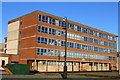
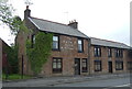
1
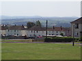
Auchinleck
Council housing in Auchinleck to the east of the B705
Image: © Angela Mudge
Taken: 19 Jul 2006
0.10 miles
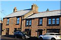
2
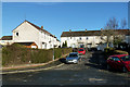
Church Street, Auchinleck
Local authority housing area in Auchinleck.
Image: © Mary and Angus Hogg
Taken: 17 Jan 2019
0.10 miles
3
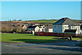
Auchinleck Outskirts
Viewed from Sorn Road looking towards Cameron Drive.
Image: © Mary and Angus Hogg
Taken: 17 Jan 2019
0.14 miles
4
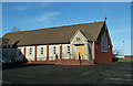
Our Lady Of Lourdes
Our Lady Of Lourdes and St Patrick's on the northern edge of Auchinleck.
Image: © Mary and Angus Hogg
Taken: 17 Jan 2019
0.17 miles
5
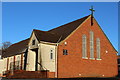
Our Lady of Lourdes & St Patrick's Catholic Church, Auchinleck
Built 1963
Image: © Leslie Barrie
Taken: 10 Nov 2013
0.18 miles
7
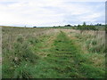
Gilminscroft railway branch
The Ordnance Survey sometimes seem slightly inconsistent in the marking of dismantled railways but this one, crossing a patch of rough ground almost opposite Auchinleck Academy is obvious to the "trained" eye even though it was closed and the track removed at least sixty years ago. The side-to-side ridges of grass indicate the placement of the wooden sleepers that supported the rails. This Glasgow & South Western Railway line branched off the Auchinleck to Muirkirk line and headed north to for just over a mile to serve four collieries at Gilminscroft, none of which survived to be nationalised in 1947. Today the railway path leads to an area of community woodland.
Image: © A-M-Jervis
Taken: 15 Sep 2007
0.22 miles
8
Auchinleck
Typical cottages on the B705 Sorn Road, Auchinleck.
This is the road to Catrine from Auchinleck and is on the main bus route to Kilmarnock.
Image: © Angela Mudge
Taken: 19 Jul 2006
0.22 miles
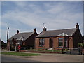
9
The Railway Hotel & Restaurant, Main Street, Auchinleck
Image: © Leslie Barrie
Taken: 10 Nov 2013
0.24 miles
10
The Railway Hotel & Restaurant, Auchinleck
On Main Street (B7083).
Image: © JThomas
Taken: 21 May 2021
0.24 miles