IMAGES TAKEN NEAR TO
CUMNOCK, KA18 2DB
Introduction
This page details the photographs taken nearby to KA18 2DB by members of the Geograph project.
The Geograph project started in 2005 with the aim of publishing, organising and preserving representative images for every square kilometre of Great Britain, Ireland and the Isle of Man.

There are currently over 7.5m images from over14,400 individuals and you can help contribute to the project by visiting https://www.geograph.org.uk
Image Map
Images are licensed for reuse under creativecommons.org/licenses/by-sa/2.0
Notes
- Clicking on the map will re-center to the selected point.
- The higher the marker number, the further away the image location is from the centre of the postcode.
Image Listing (8 Images Found)
Images are licensed for reuse under creativecommons.org/licenses/by-sa/2.0
Image
Details
Distance
1
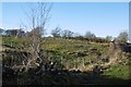
Field, Shieldburn
Beside the road at Shieldburn Bridge.
Image: © Richard Webb
Taken: 21 Jan 2017
0.13 miles
2
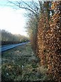
Asymmetric beech
On this Ayrshire road, the left hand hedge has been beautifully trimmed, the right-hand one neglected.
Image: © Gordon Brown
Taken: 6 Feb 2007
0.14 miles
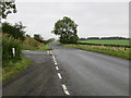
3
Road and junction, Benrigg
Road to Skares and Cumnock from Connel Park.
Image: © Richard Webb
Taken: 21 Jan 2017
0.15 miles
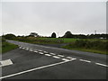
4
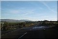
Minor road junction south of Cumnock
The distant hill to the right is The Knipe.
Image: © Gordon Brown
Taken: 6 Feb 2007
0.16 miles
5
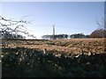
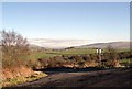
Northern slopes of Glaisnock Moss
Yet another 11KV line in the frame.
Image: © Gordon Brown
Taken: 6 Feb 2007
0.16 miles
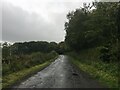
6
Road junction at the entrance to Glaisnock Moore
Looking south-westward.
Image: © Peter Wood
Taken: 12 Sep 2016
0.16 miles
8
Glaisnock Road, with lane joining from the west
Looking northward.
Image: © Peter Wood
Taken: 12 Sep 2016
0.22 miles