IMAGES TAKEN NEAR TO
Dippol Crescent, CUMNOCK, KA18 2BZ
Introduction
This page details the photographs taken nearby to Dippol Crescent, KA18 2BZ by members of the Geograph project.
The Geograph project started in 2005 with the aim of publishing, organising and preserving representative images for every square kilometre of Great Britain, Ireland and the Isle of Man.

There are currently over 7.5m images from over14,400 individuals and you can help contribute to the project by visiting https://www.geograph.org.uk
Image Map
Images are licensed for reuse under creativecommons.org/licenses/by-sa/2.0
Notes
- Clicking on the map will re-center to the selected point.
- The higher the marker number, the further away the image location is from the centre of the postcode.
Image Listing (4 Images Found)
Images are licensed for reuse under creativecommons.org/licenses/by-sa/2.0
Image
Details
Distance
1
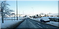
Mauchline Road, Auchinleck
A view of Mauchline Road, Auchinleck and its junction with A76 at Templeton roundabout.
Taken a few days after a heavy snowfall in December 2009.
Image: © Tom Morrison
Taken: 24 Dec 2009
0.10 miles
2
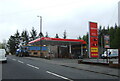
Service station on Mauchline Road (B7083), Auchinleck
Image: © JThomas
Taken: 21 May 2021
0.14 miles
3

Houses on Mauchline Road (B7083), Auchinleck
Image: © JThomas
Taken: 21 May 2021
0.16 miles
4
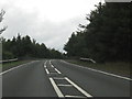
Auchinleck bypass crosses the railway line
Image: © Peter Whatley
Taken: 20 Sep 2015
0.24 miles