IMAGES TAKEN NEAR TO
Link Road, CUMNOCK, KA18 1QR
Introduction
This page details the photographs taken nearby to Link Road, KA18 1QR by members of the Geograph project.
The Geograph project started in 2005 with the aim of publishing, organising and preserving representative images for every square kilometre of Great Britain, Ireland and the Isle of Man.

There are currently over 7.5m images from over14,400 individuals and you can help contribute to the project by visiting https://www.geograph.org.uk
Image Map
Images are licensed for reuse under creativecommons.org/licenses/by-sa/2.0
Notes
- Clicking on the map will re-center to the selected point.
- The higher the marker number, the further away the image location is from the centre of the postcode.
Image Listing (7 Images Found)
Images are licensed for reuse under creativecommons.org/licenses/by-sa/2.0
Image
Details
Distance
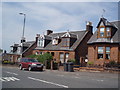
1
Steps, Townhead Street, Cumnock
Steps down from John Baird Street towards Towhead Street.
Image: © Richard Webb
Taken: 5 May 2016
0.15 miles
4
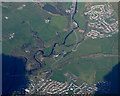
Cumnock and Logan from the air
The Category A Listed http://portal.historicenvironment.scot/designation/LB24133 nine arched former Glasgow & South Western Railway viaduct is prominent on the left. This is still in use today and carries the Kilmarnock to Dumfries line. Logan can be seen in the top right corner, skirted by the trackbed of a former railway line which can be seen joining the current line on the right.
Image: © Thomas Nugent
Taken: 17 Apr 2017
0.20 miles
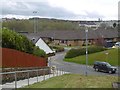
5
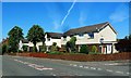
New Houses on Barrhill Road
These modern houses are located near the junction of Cumnock's Barrhill Road and Murray Court.
Image: © Mary and Angus Hogg
Taken: 31 May 2014
0.21 miles
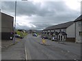
6
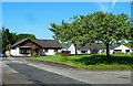
Murray Court, Cumnock
These modern houses lie just off the main A70 road through Cumnock.
Image: © Mary and Angus Hogg
Taken: 31 May 2014
0.22 miles
7
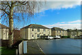
Wylie Crescent
Council housing area on the south side of Cumnock viewed from Herdston Place.
Image: © Mary and Angus Hogg
Taken: 24 Feb 2024
0.25 miles