IMAGES TAKEN NEAR TO
CUMNOCK, KA18 1NQ
Introduction
This page details the photographs taken nearby to KA18 1NQ by members of the Geograph project.
The Geograph project started in 2005 with the aim of publishing, organising and preserving representative images for every square kilometre of Great Britain, Ireland and the Isle of Man.

There are currently over 7.5m images from over14,400 individuals and you can help contribute to the project by visiting https://www.geograph.org.uk
Image Map (Loading...)


Getting Data...Please wait
Leaflet Map data © OpenStreetMap
Images are licensed for reuse under creativecommons.org/licenses/by-sa/2.0
Notes
- Clicking on the map will re-center to the selected point.
- The higher the marker number, the further away the image location is from the centre of the postcode.
Image Listing (2 Images Found)
Images are licensed for reuse under creativecommons.org/licenses/by-sa/2.0
Image
Details
Distance
1
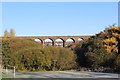
Glaisnock Viaduct, Cumnock
Thirteen span viaduct opened by the Glasgow & South-Western Railway in 1872 and now in use as a footbridge. Viewed from Murray Park.
Image: © Leslie Barrie
Taken: 10 Nov 2013
0.18 miles
2
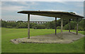
Murray Park, Cumnock
The Glaisnock Viaduct can be seen which carried the now disused Ayr- Edinburgh railway line.
Image: © Robert Watson
Taken: 22 Jul 2006
0.25 miles