IMAGES TAKEN NEAR TO
McCall Avenue, CUMNOCK, KA18 1LP
Introduction
This page details the photographs taken nearby to McCall Avenue, KA18 1LP by members of the Geograph project.
The Geograph project started in 2005 with the aim of publishing, organising and preserving representative images for every square kilometre of Great Britain, Ireland and the Isle of Man.

There are currently over 7.5m images from over14,400 individuals and you can help contribute to the project by visiting https://www.geograph.org.uk
Image Map
Images are licensed for reuse under creativecommons.org/licenses/by-sa/2.0
Notes
- Clicking on the map will re-center to the selected point.
- The higher the marker number, the further away the image location is from the centre of the postcode.
Image Listing (22 Images Found)
Images are licensed for reuse under creativecommons.org/licenses/by-sa/2.0
Image
Details
Distance
1
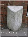
Old Milestone by the B7036, Glaisnock Road, Old Cumnock Parish
Ayr granite by the B7036, in parish of Old Cumnock (Kyle District), Cumnock, by bus stop and Nos. 161/163 Glaisnock Road, East side of road.
Inscription reads:- : New Cumnock / 5 / Dumfries / (43) : : Ayr / 16 :
Carved bench mark and rivet on top.
Surveyed
Milestone Society National ID: AYE_CMDF00
Image: © Milestone Society
Taken: Unknown
0.07 miles
2
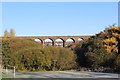
Glaisnock Viaduct, Cumnock
Thirteen span viaduct opened by the Glasgow & South-Western Railway in 1872 and now in use as a footbridge. Viewed from Murray Park.
Image: © Leslie Barrie
Taken: 10 Nov 2013
0.09 miles
3
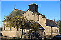
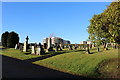
Parish Church of St John the Evangelist, Cumnock
Category B-listed. Built 1882. Architect William Burges.
Image: © Leslie Barrie
Taken: 10 Nov 2013
0.10 miles
4
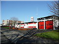
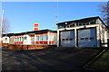
Cumnock Fire Station
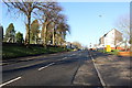
On the north side of Glaisnock Road, the old A76, to the east of the town centre.
Image: © Jonathan Billinger
Taken: 12 Feb 2008
0.11 miles
5
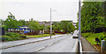
Site of Cumnock station
View SE on the A76 leaving Cumnock, where the ex-Glasgow & South Western line from Ayr via Annbank and Drongan (to the right) - (to the left) Cronberry and Muirkirk used to cross by an overbridge. The station had been on the right: it was closed along with the line Annbank - Drongan - Cronberry from 10/9/51 to passengers, 1/7/59 to goods. (See also Image]). [Apologies for an uninspiring scene].
Image: © Ben Brooksbank
Taken: 21 Jun 1994
0.12 miles
8
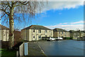
Wylie Crescent
Council housing area on the south side of Cumnock viewed from Herdston Place.
Image: © Mary and Angus Hogg
Taken: 24 Feb 2024
0.14 miles