IMAGES TAKEN NEAR TO
Oakbank Drive, CUMNOCK, KA18 1BB
Introduction
This page details the photographs taken nearby to Oakbank Drive, KA18 1BB by members of the Geograph project.
The Geograph project started in 2005 with the aim of publishing, organising and preserving representative images for every square kilometre of Great Britain, Ireland and the Isle of Man.

There are currently over 7.5m images from over14,400 individuals and you can help contribute to the project by visiting https://www.geograph.org.uk
Image Map
Images are licensed for reuse under creativecommons.org/licenses/by-sa/2.0
Notes
- Clicking on the map will re-center to the selected point.
- The higher the marker number, the further away the image location is from the centre of the postcode.
Image Listing (7 Images Found)
Images are licensed for reuse under creativecommons.org/licenses/by-sa/2.0
Image
Details
Distance
1
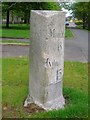
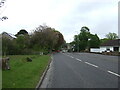
Old Milestone by the B7083, Cumnock, Auchinleck parish
Ayr granite by the B7083, Auckinleck Road, in parish of Auchinleck (East Ayrshire District), Cumnock, near mini roundabout with Holmhead Road.
Inscription reads:-
: Cumnock / ½ : : Mauchline / 6 / Kilmarnock / 15 :
Surveyed
Milestone Society National ID: AYE_KMCM15
Image: © Milestone Society
Taken: Unknown
0.19 miles
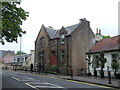
2
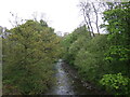
Lugar Water, Cumnock
Looking north from the bridge on the B7083.
Image: © JThomas
Taken: 21 May 2021
0.20 miles
4
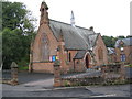
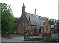
Cumnock Congregational Church
This sandstone church was dedicated in 1883 and is situated beside the River Lugar
Image: © Josie Campbell
Taken: 16 Sep 2008
0.21 miles