IMAGES TAKEN NEAR TO
Loudoun Avenue, DARVEL, KA17 0NY
Introduction
This page details the photographs taken nearby to Loudoun Avenue, KA17 0NY by members of the Geograph project.
The Geograph project started in 2005 with the aim of publishing, organising and preserving representative images for every square kilometre of Great Britain, Ireland and the Isle of Man.

There are currently over 7.5m images from over14,400 individuals and you can help contribute to the project by visiting https://www.geograph.org.uk
Image Map
Images are licensed for reuse under creativecommons.org/licenses/by-sa/2.0
Notes
- Clicking on the map will re-center to the selected point.
- The higher the marker number, the further away the image location is from the centre of the postcode.
Image Listing (9 Images Found)
Images are licensed for reuse under creativecommons.org/licenses/by-sa/2.0
Image
Details
Distance
1
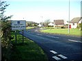
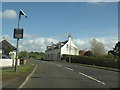
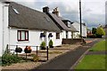
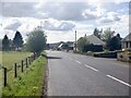
Priestland - "Gateway to Ayrshire"
Well - that's what the sign says! This former village is now attached to Darvel, one of the Ayrshire lace towns.
Image: © Gordon Brown
Taken: 15 Nov 2005
0.03 miles
5
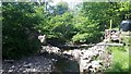
Slacks Bridge - gone!
Compare with Image Taken only one year later, this nice old stone bridge over the Gower Water is no more.
Image: © Gordon Brown
Taken: 7 Jun 2020
0.10 miles
6
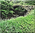
Slacks Bridge - Priestland
Slacks Bridge over Gower Water, Priestland.
Image: © Raibeart MacAoidh
Taken: 25 May 2019
0.10 miles