IMAGES TAKEN NEAR TO
DARVEL, KA17 0LQ
Introduction
This page details the photographs taken nearby to KA17 0LQ by members of the Geograph project.
The Geograph project started in 2005 with the aim of publishing, organising and preserving representative images for every square kilometre of Great Britain, Ireland and the Isle of Man.

There are currently over 7.5m images from over14,400 individuals and you can help contribute to the project by visiting https://www.geograph.org.uk
Image Map
Images are licensed for reuse under creativecommons.org/licenses/by-sa/2.0
Notes
- Clicking on the map will re-center to the selected point.
- The higher the marker number, the further away the image location is from the centre of the postcode.
Image Listing (14 Images Found)
Images are licensed for reuse under creativecommons.org/licenses/by-sa/2.0
Image
Details
Distance
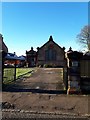
1
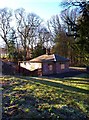
Unoccupied lodge-house
At the gates to the Lanfine Estate.
Image: © Gordon Brown
Taken: 8 Jan 2018
0.00 miles
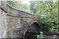
4
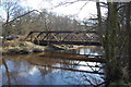
Steel Bridge
Private access bridge across River Irvine.
Image: © Scott
Taken: 28 Mar 2013
0.09 miles
5
"Mair's Old Schoolhouse", Darvel
Interesting name and interesting building, but I can't find any further information on this.
Image: © Gordon Brown
Taken: 8 Jan 2018
0.16 miles
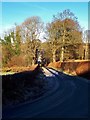
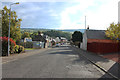
6

Darvel valley view
A quiet hack in the autumn from Lanfine estate towards the river Irvine, Darvel
Image: © Jackie Scott
Taken: 31 Oct 2004
0.17 miles
7
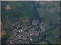
Darvel from the air
Darvel on the A71 road, at the east end of the Irvine Valley.
Image: © Thomas Nugent
Taken: 25 Sep 2017
0.18 miles
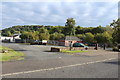
10
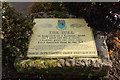
History of the Toll, Darvel
Located on Ranoldcoup road.
Image: © Billy McCrorie
Taken: 16 Oct 2015
0.21 miles