IMAGES TAKEN NEAR TO
West Main Street, DARVEL, KA17 0DX
Introduction
This page details the photographs taken nearby to West Main Street, KA17 0DX by members of the Geograph project.
The Geograph project started in 2005 with the aim of publishing, organising and preserving representative images for every square kilometre of Great Britain, Ireland and the Isle of Man.

There are currently over 7.5m images from over14,400 individuals and you can help contribute to the project by visiting https://www.geograph.org.uk
Image Map
Images are licensed for reuse under creativecommons.org/licenses/by-sa/2.0
Notes
- Clicking on the map will re-center to the selected point.
- The higher the marker number, the further away the image location is from the centre of the postcode.
Image Listing (54 Images Found)
Images are licensed for reuse under creativecommons.org/licenses/by-sa/2.0
Image
Details
Distance
1
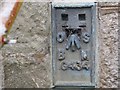
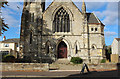
Ordnance Survey Flush Bracket G434
This can be found on the wall of a former church - now a private dwelling and day nursery - in Darvel.
For more detail see : http://www.bench-marks.org.uk/bm130
Image: © Peter Wood
Taken: 14 Sep 2016
0.01 miles
4
Former Easton Memorial Church, Darvel
Image: © Billy McCrorie
Taken: 16 Oct 2015
0.02 miles
5
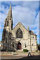
Former Easton Memorial Church, Darvel
Image: © Billy McCrorie
Taken: 16 Oct 2015
0.02 miles
7
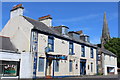
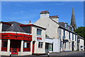
The Turf Hotel, West Main Street, Darvel
Category B-listed. Built c1840
Image: © Leslie Barrie
Taken: 31 May 2014
0.03 miles
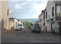
9
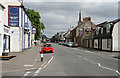
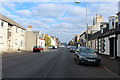
The A71 through Darvel
A view eastwards through the town. The Turf Hotel on the left is closed.
Image: © Walter Baxter
Taken: 12 Jun 2010
0.04 miles