IMAGES TAKEN NEAR TO
Drumclog Crescent, DARVEL, KA17 0BA
Introduction
This page details the photographs taken nearby to Drumclog Crescent, KA17 0BA by members of the Geograph project.
The Geograph project started in 2005 with the aim of publishing, organising and preserving representative images for every square kilometre of Great Britain, Ireland and the Isle of Man.

There are currently over 7.5m images from over14,400 individuals and you can help contribute to the project by visiting https://www.geograph.org.uk
Image Map
Images are licensed for reuse under creativecommons.org/licenses/by-sa/2.0
Notes
- Clicking on the map will re-center to the selected point.
- The higher the marker number, the further away the image location is from the centre of the postcode.
Image Listing (19 Images Found)
Images are licensed for reuse under creativecommons.org/licenses/by-sa/2.0
Image
Details
Distance
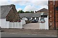
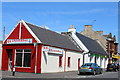
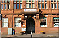
3
Loudoun Valley Manufacturing Co Ltd, Darvel
Vacant business premises on Jamieson Road
Image: © Leslie Barrie
Taken: 31 May 2014
0.13 miles
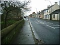
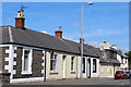
6
East Main Street, Darvel
At the corner of Jamieson Road
Image: © Leslie Barrie
Taken: 31 May 2014
0.18 miles
7
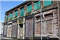
Darvel Industrial Co-Operative Society Ltd Registered Offices
Derelict building on Ranoldcoup Road
Image: © Leslie Barrie
Taken: 31 May 2014
0.22 miles
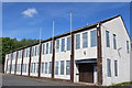
8
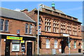
Darvel Town Hall
Category B-listed. Built late 19th-early 20th century.
Image: © Leslie Barrie
Taken: 31 May 2014
0.23 miles
10
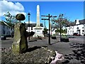
The Dagon Stone - Hastings Square, Darvel
The Dagon Stone has been moved and re-erected on more than one occasion.In 1961-2 it was moved to its present position in Hastings Square. In 1821 William Morton, a local blacksmith attached a round sandstone ball to the top of it with an iron bar, the large round stone having been found when locals were digging a curling pond.
Image: © Raibeart MacAoidh
Taken: 4 May 2019
0.24 miles