IMAGES TAKEN NEAR TO
NEWMILNS, KA16 9LG
Introduction
This page details the photographs taken nearby to KA16 9LG by members of the Geograph project.
The Geograph project started in 2005 with the aim of publishing, organising and preserving representative images for every square kilometre of Great Britain, Ireland and the Isle of Man.

There are currently over 7.5m images from over14,400 individuals and you can help contribute to the project by visiting https://www.geograph.org.uk
Image Map
Images are licensed for reuse under creativecommons.org/licenses/by-sa/2.0
Notes
- Clicking on the map will re-center to the selected point.
- The higher the marker number, the further away the image location is from the centre of the postcode.
Image Listing (5 Images Found)
Images are licensed for reuse under creativecommons.org/licenses/by-sa/2.0
Image
Details
Distance
1
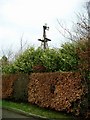
Derelict windpump
Peeping over the shrubbery, this machine does not look as though it has been in use for some considerable time - but still marked on all the OS maps.
Image: © Gordon Brown
Taken: 15 Feb 2007
0.03 miles
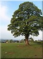
2

Minor road between Loudoun Mains & West Heads
Image: © Leslie Barrie
Taken: 31 May 2014
0.11 miles
4
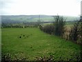
The slopes down to Newmilns
The lace manufacturing town of Newmilns is hidden in the valley below these slopes.
Image: © Gordon Brown
Taken: 15 Feb 2007
0.19 miles
5
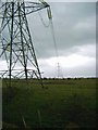
400 Kvolts
Power line joining sub-station near Kilmarnock to another substation at Dykend, Hamilton
Image: © Gordon Brown
Taken: 15 Feb 2007
0.24 miles