IMAGES TAKEN NEAR TO
Alstonpapple, NEWMILNS, KA16 9LA
Introduction
This page details the photographs taken nearby to Alstonpapple, KA16 9LA by members of the Geograph project.
The Geograph project started in 2005 with the aim of publishing, organising and preserving representative images for every square kilometre of Great Britain, Ireland and the Isle of Man.

There are currently over 7.5m images from over14,400 individuals and you can help contribute to the project by visiting https://www.geograph.org.uk
Image Map
Images are licensed for reuse under creativecommons.org/licenses/by-sa/2.0
Notes
- Clicking on the map will re-center to the selected point.
- The higher the marker number, the further away the image location is from the centre of the postcode.
Image Listing (2 Images Found)
Images are licensed for reuse under creativecommons.org/licenses/by-sa/2.0
Image
Details
Distance
1
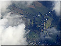
Newmilns from the air
The east end of Newmilns, around Darvel Road.
Image: © Thomas Nugent
Taken: 27 Jan 2020
0.03 miles
2

Darvel from the air
The easternmost of the Irvine Valley towns, the others being Galston and Newmilns.
Image: © Thomas Nugent
Taken: 11 Feb 2019
0.17 miles