IMAGES TAKEN NEAR TO
Darnleyhill Walk, NEWMILNS, KA16 9ES
Introduction
This page details the photographs taken nearby to Darnleyhill Walk, KA16 9ES by members of the Geograph project.
The Geograph project started in 2005 with the aim of publishing, organising and preserving representative images for every square kilometre of Great Britain, Ireland and the Isle of Man.

There are currently over 7.5m images from over14,400 individuals and you can help contribute to the project by visiting https://www.geograph.org.uk
Image Map
Images are licensed for reuse under creativecommons.org/licenses/by-sa/2.0
Notes
- Clicking on the map will re-center to the selected point.
- The higher the marker number, the further away the image location is from the centre of the postcode.
Image Listing (11 Images Found)
Images are licensed for reuse under creativecommons.org/licenses/by-sa/2.0
Image
Details
Distance
3
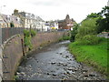
River Irvine at Newmilns
At this point the River Irvine is flowing just beside the A71 as it passes through Newmilns.
Image: © G Laird
Taken: 22 Aug 2017
0.18 miles
6
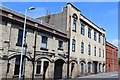
Irvinebank Powerloom Factory, Brown Street, Newmilns
Built 1877 and rebuilt following fire damage in 1923. Latterly premises of the Vesuvius Group.
Image: © Leslie Barrie
Taken: 31 May 2014
0.23 miles
8
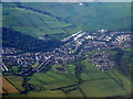
Newmilns from the air
The cemetery is towards the lower left corner of this photo which was taken from a Glasgow bound flight from Luton.
Image: © Thomas Nugent
Taken: 4 Sep 2010
0.25 miles
9
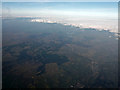
Whitelee wind farm from the air
Newmilns and Darvel can be seen in the lower right corner.
Image: © Thomas Nugent
Taken: 18 Mar 2015
0.25 miles