IMAGES TAKEN NEAR TO
Coodham, KILMARNOCK, KA1 5SG
Introduction
This page details the photographs taken nearby to Coodham, KA1 5SG by members of the Geograph project.
The Geograph project started in 2005 with the aim of publishing, organising and preserving representative images for every square kilometre of Great Britain, Ireland and the Isle of Man.

There are currently over 7.5m images from over14,400 individuals and you can help contribute to the project by visiting https://www.geograph.org.uk
Image Map
Images are licensed for reuse under creativecommons.org/licenses/by-sa/2.0
Notes
- Clicking on the map will re-center to the selected point.
- The higher the marker number, the further away the image location is from the centre of the postcode.
Image Listing (17 Images Found)
Images are licensed for reuse under creativecommons.org/licenses/by-sa/2.0
Image
Details
Distance
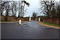
1
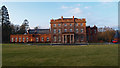
Coodham House
Country house converted to apartments. Alternative names are Fatima House; Williamfield House.
Image: © wfmillar
Taken: 16 Jan 2012
0.02 miles
2
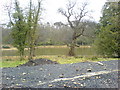
Coodham Lake
The northwest end of Coodham Lake.
Image: © David Johnston
Taken: 26 Mar 2008
0.12 miles
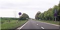
3
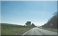
Speed limit and other signs
Signs on the A77 limiting speed to 50 MPH with averaging speed cameras to make sure everyone does keep to the limit.
Image: © Malcolm Neal
Taken: 9 Apr 2019
0.19 miles
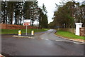
8
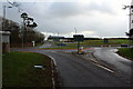
New Road Layout at Bogend
For Tarbolton you used to go straight ahead and struggle to get over the busy A77, now thanks to the new layout you go to the right and over the A77 a great improvement.
Image: © Billy McCrorie
Taken: 20 Dec 2014
0.20 miles
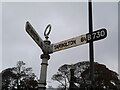
9
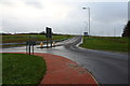
New Road Layout at Bogend
Road now going over the busy A77.
Image: © Billy McCrorie
Taken: 20 Dec 2014
0.20 miles