IMAGES TAKEN NEAR TO
Symington, KILMARNOCK, KA1 5QW
Introduction
This page details the photographs taken nearby to KA1 5QW by members of the Geograph project.
The Geograph project started in 2005 with the aim of publishing, organising and preserving representative images for every square kilometre of Great Britain, Ireland and the Isle of Man.

There are currently over 7.5m images from over14,400 individuals and you can help contribute to the project by visiting https://www.geograph.org.uk
Image Map
Images are licensed for reuse under creativecommons.org/licenses/by-sa/2.0
Notes
- Clicking on the map will re-center to the selected point.
- The higher the marker number, the further away the image location is from the centre of the postcode.
Image Listing (5 Images Found)
Images are licensed for reuse under creativecommons.org/licenses/by-sa/2.0
Image
Details
Distance
1
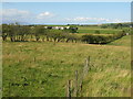
Low Wexford
Pasture near Symington, seen from the bus top on the A77 at Hansel Village.
Image: © M J Richardson
Taken: 5 Sep 2013
0.09 miles
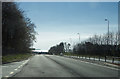
2
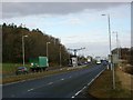
A77 with average speed cameras
In this picture can be seen the average speed cameras on their central gantry. About 30 miles of the A77 is covered by these devices.
Image: © Gordon Brown
Taken: 29 Nov 2005
0.23 miles
3
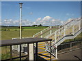
Bus stop and footbridge at Hansel Village
Looking north across pasture. The bridge crosses the A77 and leads to Hansel Village, which is associated with 'elderly people' warning signs on the fast dual carriageway [e.g. Image ].
Image: © M J Richardson
Taken: 5 Sep 2013
0.24 miles
4
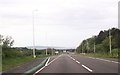
A distant view of the sea
As the road drops down ahead we can see the sea dazzling in the afternoon sun. The road markings on the A77 however do seem rather worn out.
Image: © Malcolm Neal
Taken: 9 Apr 2019
0.25 miles