IMAGES TAKEN NEAR TO
Symington Road North, KILMARNOCK, KA1 5PZ
Introduction
This page details the photographs taken nearby to Symington Road North, KA1 5PZ by members of the Geograph project.
The Geograph project started in 2005 with the aim of publishing, organising and preserving representative images for every square kilometre of Great Britain, Ireland and the Isle of Man.

There are currently over 7.5m images from over14,400 individuals and you can help contribute to the project by visiting https://www.geograph.org.uk
Image Map
Images are licensed for reuse under creativecommons.org/licenses/by-sa/2.0
Notes
- Clicking on the map will re-center to the selected point.
- The higher the marker number, the further away the image location is from the centre of the postcode.
Image Listing (53 Images Found)
Images are licensed for reuse under creativecommons.org/licenses/by-sa/2.0
Image
Details
Distance
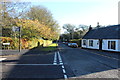
1
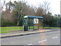
Bus stop at Symington
For buses heading north towards Kilmarnock.
Image: © M J Richardson
Taken: 14 Apr 2012
0.04 miles
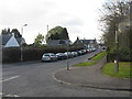
3
Brewlands Road, Symington, South Ayrshire
The terraced cottage on the right is The Schoolhouse.
Image: © Mark S
Taken: 30 Sep 2023
0.08 miles
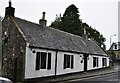
4
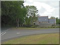
The old school
Formerly Symington school building, now residential.
Image: © James Allan
Taken: 7 Jun 2006
0.09 miles
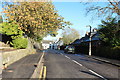
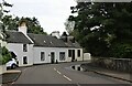
6
Main Street Symington
With the Wheatsheaf Inn on the left.
Image: © M J Richardson
Taken: 14 Apr 2012
0.09 miles
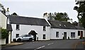
8
Wheatsheaf Inn, Symington, South Ayrshire
Category C-listed, built some time in the 18th century.
Image: © Mark S
Taken: 30 Sep 2023
0.09 miles
9
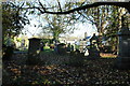
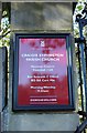
Craigie Symington Parish Church Graveyard
Image: © Billy McCrorie
Taken: 2 Nov 2017
0.09 miles