IMAGES TAKEN NEAR TO
Kilmarnock Road, KILMARNOCK, KA1 5PW
Introduction
This page details the photographs taken nearby to Kilmarnock Road, KA1 5PW by members of the Geograph project.
The Geograph project started in 2005 with the aim of publishing, organising and preserving representative images for every square kilometre of Great Britain, Ireland and the Isle of Man.

There are currently over 7.5m images from over14,400 individuals and you can help contribute to the project by visiting https://www.geograph.org.uk
Image Map
Images are licensed for reuse under creativecommons.org/licenses/by-sa/2.0
Notes
- Clicking on the map will re-center to the selected point.
- The higher the marker number, the further away the image location is from the centre of the postcode.
Image Listing (4 Images Found)
Images are licensed for reuse under creativecommons.org/licenses/by-sa/2.0
Image
Details
Distance
1
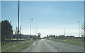
Passing Whitelees
Whitelees is a small collection of buildings to the left of the A77 at this point.
Image: © Malcolm Neal
Taken: 9 Apr 2019
0.01 miles
3
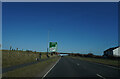
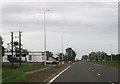
On the A77
Travelling towards Kilmarnock on the A77, the traffic at this point was quite light.
Image: © Malcolm Neal
Taken: 20 Mar 2022
0.16 miles
4
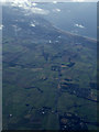
The A77 and Prestwick Airport from the air
The only clear stretch of land on an otherwise cloudy day seen from a flight from Glasgow to Heathrow.
Image: © Thomas Nugent
Taken: 16 Feb 2015
0.21 miles