IMAGES TAKEN NEAR TO
Symington, KILMARNOCK, KA1 5PP
Introduction
This page details the photographs taken nearby to KA1 5PP by members of the Geograph project.
The Geograph project started in 2005 with the aim of publishing, organising and preserving representative images for every square kilometre of Great Britain, Ireland and the Isle of Man.

There are currently over 7.5m images from over14,400 individuals and you can help contribute to the project by visiting https://www.geograph.org.uk
Image Map
Images are licensed for reuse under creativecommons.org/licenses/by-sa/2.0
Notes
- Clicking on the map will re-center to the selected point.
- The higher the marker number, the further away the image location is from the centre of the postcode.
Image Listing (4 Images Found)
Images are licensed for reuse under creativecommons.org/licenses/by-sa/2.0
Image
Details
Distance
2
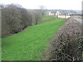
Wooded Glen
The house hidden in the trees is called Motte House. Great snowdrops in the glen.
Image: © wfmillar
Taken: 16 Feb 2007
0.11 miles
3
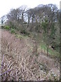
Helenton Motte
Viewed from the public road, this ancient motte lies in a private garden.
Image: © Mary and Angus Hogg
Taken: 27 Apr 2016
0.19 miles
4
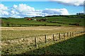
Helenton Farmland View
Grazing land and arable fields in central Ayrshire, near Symington. Heughmill Farm is shown in the background, in the next square.
Image: © Mary and Angus Hogg
Taken: 5 Mar 2017
0.20 miles