IMAGES TAKEN NEAR TO
Ayr Road, KILMARNOCK, KA1 5NX
Introduction
This page details the photographs taken nearby to Ayr Road, KA1 5NX by members of the Geograph project.
The Geograph project started in 2005 with the aim of publishing, organising and preserving representative images for every square kilometre of Great Britain, Ireland and the Isle of Man.

There are currently over 7.5m images from over14,400 individuals and you can help contribute to the project by visiting https://www.geograph.org.uk
Image Map
Images are licensed for reuse under creativecommons.org/licenses/by-sa/2.0
Notes
- Clicking on the map will re-center to the selected point.
- The higher the marker number, the further away the image location is from the centre of the postcode.
Image Listing (5 Images Found)
Images are licensed for reuse under creativecommons.org/licenses/by-sa/2.0
Image
Details
Distance
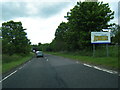
1
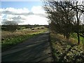
The road to Spittalhill
Slip road from the A77 dual carriageway to the left.
Image: © Gordon Brown
Taken: 1 Mar 2007
0.08 miles
3
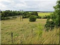
A little used field
At a road junction on the A77, this field is probably languishing in a developer's land bank. It has not been grazed for a while.
Image: © Richard Webb
Taken: 13 Aug 2014
0.14 miles
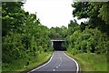
4
On the A77 slip road
We are about to pass under the A77 so that we can join the road on the left as it goes towards Ayr.
Image: © Malcolm Neal
Taken: 9 Apr 2019
0.15 miles
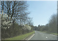
5
B7038 nears the A77 at the South Ayrshire boundary
Image: © Colin Pyle
Taken: 4 Jun 2013
0.17 miles