IMAGES TAKEN NEAR TO
Craigie, KILMARNOCK, KA1 5LR
Introduction
This page details the photographs taken nearby to KA1 5LR by members of the Geograph project.
The Geograph project started in 2005 with the aim of publishing, organising and preserving representative images for every square kilometre of Great Britain, Ireland and the Isle of Man.

There are currently over 7.5m images from over14,400 individuals and you can help contribute to the project by visiting https://www.geograph.org.uk
Image Map
Images are licensed for reuse under creativecommons.org/licenses/by-sa/2.0
Notes
- Clicking on the map will re-center to the selected point.
- The higher the marker number, the further away the image location is from the centre of the postcode.
Image Listing (5 Images Found)
Images are licensed for reuse under creativecommons.org/licenses/by-sa/2.0
Image
Details
Distance
3
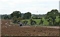
Gulls following the plough at Knockmarloch
Image: © Alan Reid
Taken: 15 Sep 2021
0.09 miles
4
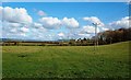
Towards Wester Hillhouse
A springtime view of central Ayrshire's grazing land near Kilmarnock. Wester Hillhouse farm lies in the next square.
Image: © Mary and Angus Hogg
Taken: 5 Mar 2017
0.11 miles
5
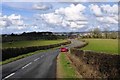
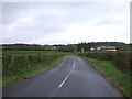
On The Craigie Road
An early-spring view of this minor road looking towards Kilmarnock.
Image: © Mary and Angus Hogg
Taken: 5 Mar 2017
0.13 miles