IMAGES TAKEN NEAR TO
Hurlford, KILMARNOCK, KA1 5JN
Introduction
This page details the photographs taken nearby to KA1 5JN by members of the Geograph project.
The Geograph project started in 2005 with the aim of publishing, organising and preserving representative images for every square kilometre of Great Britain, Ireland and the Isle of Man.

There are currently over 7.5m images from over14,400 individuals and you can help contribute to the project by visiting https://www.geograph.org.uk
Image Map
Images are licensed for reuse under creativecommons.org/licenses/by-sa/2.0
Notes
- Clicking on the map will re-center to the selected point.
- The higher the marker number, the further away the image location is from the centre of the postcode.
Image Listing (3 Images Found)
Images are licensed for reuse under creativecommons.org/licenses/by-sa/2.0
Image
Details
Distance
1
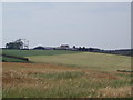
Aird Farm
Aird Farm seen from the A719, just after Crossroads
Image: © Angela Mudge
Taken: 19 Jul 2006
0.08 miles
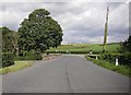
3
This way to Ayr
Looking along the A713 near the Crossroads roundabout.
Image: © Mary and Angus Hogg
Taken: 8 Aug 2020
0.22 miles