IMAGES TAKEN NEAR TO
Muggersland Burn, KILMARNOCK, KA1 5HX
Introduction
This page details the photographs taken nearby to Muggersland Burn, KA1 5HX by members of the Geograph project.
The Geograph project started in 2005 with the aim of publishing, organising and preserving representative images for every square kilometre of Great Britain, Ireland and the Isle of Man.

There are currently over 7.5m images from over14,400 individuals and you can help contribute to the project by visiting https://www.geograph.org.uk
Image Map
Images are licensed for reuse under creativecommons.org/licenses/by-sa/2.0
Notes
- Clicking on the map will re-center to the selected point.
- The higher the marker number, the further away the image location is from the centre of the postcode.
Image Listing (3 Images Found)
Images are licensed for reuse under creativecommons.org/licenses/by-sa/2.0
Image
Details
Distance
2
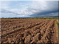
Newly Ploughed Field
View towards Kilmarnock with a weather front approaching.
Image: © wfmillar
Taken: 2 Apr 2012
0.17 miles
3
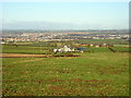
Hirst From Maintree
... with Kilmarnock in background
Image: © Iain Thompson
Taken: 8 Dec 2006
0.23 miles