IMAGES TAKEN NEAR TO
Tower Place, KILMARNOCK, KA1 5HL
Introduction
This page details the photographs taken nearby to Tower Place, KA1 5HL by members of the Geograph project.
The Geograph project started in 2005 with the aim of publishing, organising and preserving representative images for every square kilometre of Great Britain, Ireland and the Isle of Man.

There are currently over 7.5m images from over14,400 individuals and you can help contribute to the project by visiting https://www.geograph.org.uk
Image Map
Images are licensed for reuse under creativecommons.org/licenses/by-sa/2.0
Notes
- Clicking on the map will re-center to the selected point.
- The higher the marker number, the further away the image location is from the centre of the postcode.
Image Listing (21 Images Found)
Images are licensed for reuse under creativecommons.org/licenses/by-sa/2.0
Image
Details
Distance

4
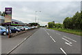
Ayr Road, Kilmarnock
Garden centre on the left.
Image: © Billy McCrorie
Taken: 22 May 2014
0.08 miles
5
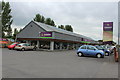
DeWaldens Garden Centre, Kilmarnock
And coffee shop.
Image: © Billy McCrorie
Taken: 22 May 2014
0.08 miles


8
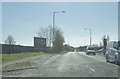
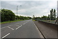
Leaving Kilmarnock
We are on the B7038 Ayr Road as we leave Kilmarnock.
Image: © Malcolm Neal
Taken: 9 Apr 2019
0.10 miles