IMAGES TAKEN NEAR TO
Kerrmuir Avenue, KILMARNOCK, KA1 5EP
Introduction
This page details the photographs taken nearby to Kerrmuir Avenue, KA1 5EP by members of the Geograph project.
The Geograph project started in 2005 with the aim of publishing, organising and preserving representative images for every square kilometre of Great Britain, Ireland and the Isle of Man.

There are currently over 7.5m images from over14,400 individuals and you can help contribute to the project by visiting https://www.geograph.org.uk
Image Map
Images are licensed for reuse under creativecommons.org/licenses/by-sa/2.0
Notes
- Clicking on the map will re-center to the selected point.
- The higher the marker number, the further away the image location is from the centre of the postcode.
Image Listing (6 Images Found)
Images are licensed for reuse under creativecommons.org/licenses/by-sa/2.0
Image
Details
Distance
1
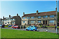
The last houses in Hurlford
These houses on the SE edge of Hurlford enjoy a sunny aspect with decent views.
Image: © Mary and Angus Hogg
Taken: 13 Aug 2020
0.13 miles
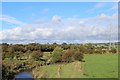
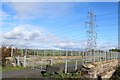
2
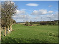
Edge of Hurlford
Under the pylons the River Cessnock can just be seen.
Image: © wfmillar
Taken: 1 Mar 2007
0.18 miles
3
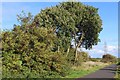
Chris Hoy Cycle Way
Follows the dismantled railway from Hurlford to Galston
Image: © Leslie Barrie
Taken: 5 Oct 2013
0.19 miles
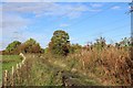
6
Chris Hoy Cycle Way
Follows the dismantled railway from Hurlford to Galston
Image: © Leslie Barrie
Taken: 5 Oct 2013
0.24 miles