IMAGES TAKEN NEAR TO
Riccarton Road, KILMARNOCK, KA1 5AQ
Introduction
This page details the photographs taken nearby to Riccarton Road, KA1 5AQ by members of the Geograph project.
The Geograph project started in 2005 with the aim of publishing, organising and preserving representative images for every square kilometre of Great Britain, Ireland and the Isle of Man.

There are currently over 7.5m images from over14,400 individuals and you can help contribute to the project by visiting https://www.geograph.org.uk
Image Map
Images are licensed for reuse under creativecommons.org/licenses/by-sa/2.0
Notes
- Clicking on the map will re-center to the selected point.
- The higher the marker number, the further away the image location is from the centre of the postcode.
Image Listing (47 Images Found)
Images are licensed for reuse under creativecommons.org/licenses/by-sa/2.0
Image
Details
Distance
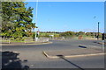
1
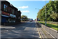
The Thistle, Hurlford
Pub on Riccarton Road
Image: © Leslie Barrie
Taken: 5 Oct 2013
0.02 miles
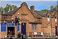
3
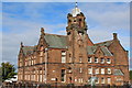
Hurlford Primary School
Category B-listed. Built 1905. Architects Andrew & Newlands.
Image: © Leslie Barrie
Taken: 5 Oct 2013
0.06 miles
4
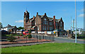
Hurlford Primary School
The building now also accommodates Hurlford Early Childhood Centre. Viewed from Academy Street.
Image: © Mary and Angus Hogg
Taken: 13 Aug 2020
0.06 miles
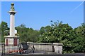
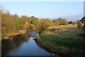
7
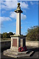
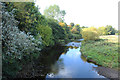
Crookedholm, Hulford Bridge, War Memorial
Image: © Billy McCrorie
Taken: 16 Oct 2015
0.08 miles
8
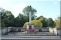
Crookedholm, Hulford Bridge, War Memorial
Image: © Billy McCrorie
Taken: 16 Oct 2015
0.08 miles