IMAGES TAKEN NEAR TO
BEITH, KA15 2JS
Introduction
This page details the photographs taken nearby to KA15 2JS by members of the Geograph project.
The Geograph project started in 2005 with the aim of publishing, organising and preserving representative images for every square kilometre of Great Britain, Ireland and the Isle of Man.

There are currently over 7.5m images from over14,400 individuals and you can help contribute to the project by visiting https://www.geograph.org.uk
Image Map
Images are licensed for reuse under creativecommons.org/licenses/by-sa/2.0
Notes
- Clicking on the map will re-center to the selected point.
- The higher the marker number, the further away the image location is from the centre of the postcode.
Image Listing (4 Images Found)
Images are licensed for reuse under creativecommons.org/licenses/by-sa/2.0
Image
Details
Distance
1
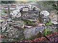
St Inan's Well
St Inan reputed to have come over from Ireland in the 9th century, with local legend saying he preached to the people from a rock formation in the hillside
above the well known as St Inan's chair.
Image: © Chris Court
Taken: 26 Nov 2005
0.13 miles
2
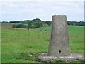
Lochlands Hill trig point.
In dairy farming country.
Image: © Richard Webb
Taken: 24 Jul 2005
0.17 miles
3
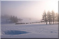
Golf Course, Beith
Afternoon mist covers a wintry course.
Image: © wfmillar
Taken: 25 Dec 2009
0.21 miles
4
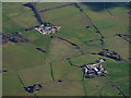
Hoodsyard farm and Cuff Farm from the air
Hoodsyard is nearer the camera.
Image: © Thomas Nugent
Taken: 17 Apr 2017
0.25 miles