IMAGES TAKEN NEAR TO
BEITH, KA15 2JN
Introduction
This page details the photographs taken nearby to KA15 2JN by members of the Geograph project.
The Geograph project started in 2005 with the aim of publishing, organising and preserving representative images for every square kilometre of Great Britain, Ireland and the Isle of Man.

There are currently over 7.5m images from over14,400 individuals and you can help contribute to the project by visiting https://www.geograph.org.uk
Image Map
Images are licensed for reuse under creativecommons.org/licenses/by-sa/2.0
Notes
- Clicking on the map will re-center to the selected point.
- The higher the marker number, the further away the image location is from the centre of the postcode.
Image Listing (7 Images Found)
Images are licensed for reuse under creativecommons.org/licenses/by-sa/2.0
Image
Details
Distance
2
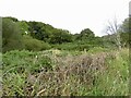
Scrub near Mill of Beith
Above the Roebank Burn.
Image: © Richard Webb
Taken: 17 Sep 2022
0.06 miles
3
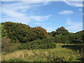
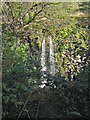
Hidden Roebank Burn, Beith
The burn runs below the trees.
Image: © wfmillar
Taken: 5 Oct 2007
0.11 miles
4
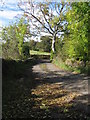
Mill of Beith Bridge
Crossing Roebank Burn.
Image: © wfmillar
Taken: 5 Oct 2007
0.12 miles
5
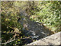
Roebank Burn, Beith
This is Roebank Burn, taken from Beith Mill Bridge.
Image: © Ian Golds
Taken: 28 Sep 2011
0.12 miles
7
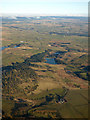
Brownmuir from the air
Kirkleegreen Reservoir is near the centre of the photo.
Image: © Thomas Nugent
Taken: 16 Mar 2016
0.20 miles