IMAGES TAKEN NEAR TO
Threepwood Road, BEITH, KA15 2JJ
Introduction
This page details the photographs taken nearby to Threepwood Road, KA15 2JJ by members of the Geograph project.
The Geograph project started in 2005 with the aim of publishing, organising and preserving representative images for every square kilometre of Great Britain, Ireland and the Isle of Man.

There are currently over 7.5m images from over14,400 individuals and you can help contribute to the project by visiting https://www.geograph.org.uk
Image Map
Images are licensed for reuse under creativecommons.org/licenses/by-sa/2.0
Notes
- Clicking on the map will re-center to the selected point.
- The higher the marker number, the further away the image location is from the centre of the postcode.
Image Listing (27 Images Found)
Images are licensed for reuse under creativecommons.org/licenses/by-sa/2.0
Image
Details
Distance
2
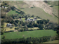
Grangehill from the air
With Threepwood Road beyond.
Image: © Thomas Nugent
Taken: 21 Apr 2022
0.10 miles
3
Field, Grangehill Estate, Beith
Used for general grazing.
Image: © wfmillar
Taken: 14 Dec 2010
0.10 miles
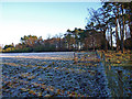
4
Frosty Field
Grangehill Estate after a frost.
Image: © wfmillar
Taken: 30 Nov 2008
0.11 miles
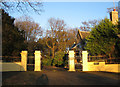
6
Open gate, Grangehill Estate, Beith
Cattle are allowed to graze amongst the trees on the right.
Image: © wfmillar
Taken: 14 Dec 2010
0.12 miles
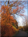
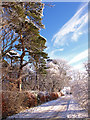
7
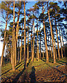
Pine Trees, Beith
In Grangehill Estate. Winter sun casts long shadows.
Image: © wfmillar
Taken: 14 Dec 2010
0.14 miles
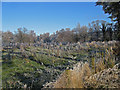
8
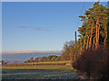
Field Boundaries, Beith
In the grounds of Grangehill Estate.
Image: © wfmillar
Taken: 14 Dec 2010
0.15 miles
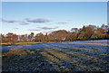
10
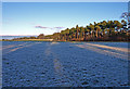
Frosty Field, Beith
The low winter sun does not reach much of this field.
Image: © wfmillar
Taken: 14 Dec 2010
0.17 miles