IMAGES TAKEN NEAR TO
BEITH, KA15 2JF
Introduction
This page details the photographs taken nearby to KA15 2JF by members of the Geograph project.
The Geograph project started in 2005 with the aim of publishing, organising and preserving representative images for every square kilometre of Great Britain, Ireland and the Isle of Man.

There are currently over 7.5m images from over14,400 individuals and you can help contribute to the project by visiting https://www.geograph.org.uk
Image Map
Images are licensed for reuse under creativecommons.org/licenses/by-sa/2.0
Notes
- Clicking on the map will re-center to the selected point.
- The higher the marker number, the further away the image location is from the centre of the postcode.
Image Listing (16 Images Found)
Images are licensed for reuse under creativecommons.org/licenses/by-sa/2.0
Image
Details
Distance
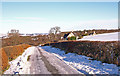
1
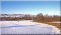
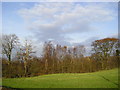
Woodside Estate, Beith
Minor road on the right circles the estate and gives a great short walk.
Image: © wfmillar
Taken: 5 Dec 2010
0.03 miles
3
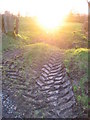
Tractor Tracks
After an icy morning the farmers take to the otherwise very wet fields.
Image: © wfmillar
Taken: 5 Feb 2007
0.05 miles
4
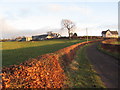
Southridgehill Farm
Original farm on left and new farm house on the right.
Image: © wfmillar
Taken: 5 Feb 2007
0.07 miles
5
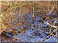
Roebank burn, beith
The burn flows through a very wooded glen. Viewed through Beech tree branches.
Image: © wfmillar
Taken: 5 Dec 2010
0.07 miles
6
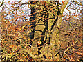
Birches
Birch Trees in winter sunshine above the Roebank Burn.
Image: © Chris Court
Taken: 20 Nov 2005
0.08 miles
8
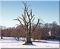
Dead Tree, Woodside Estate
Could be an Elm tree. Woodside House in the trees to the right.
Image: © wfmillar
Taken: 5 Dec 2010
0.08 miles
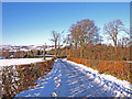
9
Southridgehill Farm Road, Beith
Original farm buildings behind the new farm house.
Image: © wfmillar
Taken: 5 Dec 2010
0.08 miles
10
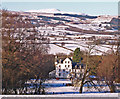
Woodside House, Beith
Misty Law on the sky line.
Image: © wfmillar
Taken: 5 Dec 2010
0.16 miles