IMAGES TAKEN NEAR TO
Kirk View, BEITH, KA15 2EL
Introduction
This page details the photographs taken nearby to Kirk View, KA15 2EL by members of the Geograph project.
The Geograph project started in 2005 with the aim of publishing, organising and preserving representative images for every square kilometre of Great Britain, Ireland and the Isle of Man.

There are currently over 7.5m images from over14,400 individuals and you can help contribute to the project by visiting https://www.geograph.org.uk
Image Map
Images are licensed for reuse under creativecommons.org/licenses/by-sa/2.0
Notes
- Clicking on the map will re-center to the selected point.
- The higher the marker number, the further away the image location is from the centre of the postcode.
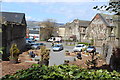
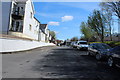
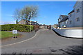
Image Listing (115 Images Found)
Images are licensed for reuse under creativecommons.org/licenses/by-sa/2.0
Image
Details
Distance
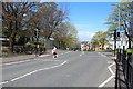
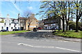
5
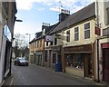
Main Street, Beith
Partially pedestrianised.
Image: © Richard Webb
Taken: 15 Nov 2014
0.04 miles
8
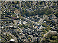
Beith from the air
Main Street and Bellman's Close are in the foreground.
Image: © Thomas Nugent
Taken: 21 Apr 2022
0.04 miles