IMAGES TAKEN NEAR TO
Kings Road, BEITH, KA15 2BQ
Introduction
This page details the photographs taken nearby to Kings Road, KA15 2BQ by members of the Geograph project.
The Geograph project started in 2005 with the aim of publishing, organising and preserving representative images for every square kilometre of Great Britain, Ireland and the Isle of Man.

There are currently over 7.5m images from over14,400 individuals and you can help contribute to the project by visiting https://www.geograph.org.uk
Image Map
Images are licensed for reuse under creativecommons.org/licenses/by-sa/2.0
Notes
- Clicking on the map will re-center to the selected point.
- The higher the marker number, the further away the image location is from the centre of the postcode.
Image Listing (136 Images Found)
Images are licensed for reuse under creativecommons.org/licenses/by-sa/2.0
Image
Details
Distance
1
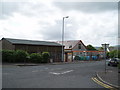
Telephone Exchange Beith
Telephone Exchange on Kings Road Beith. Community hall is to the right of the exchange. 26th July 2009 3.30p.m.
Image: © Gordon Dowie
Taken: 26 Jul 2009
0.03 miles
2
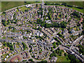
Beith from the air
Looking over the centre of Beith village towards the A737 Bypass Road.
Image: © Thomas Nugent
Taken: 28 Jun 2019
0.03 miles
7
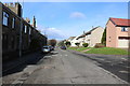
Caledonia Road, Beith
Building straight ahead in the centre is the Co-op.
Image: © Billy McCrorie
Taken: 4 Mar 2019
0.07 miles
8
Medine Place in sun, Beith
Rear of E.U. Church on the left. Police station (disused) centre left.
Image: © wfmillar
Taken: 8 Dec 2010
0.07 miles