IMAGES TAKEN NEAR TO
Blackthorn Avenue, BEITH, KA15 2AR
Introduction
This page details the photographs taken nearby to Blackthorn Avenue, KA15 2AR by members of the Geograph project.
The Geograph project started in 2005 with the aim of publishing, organising and preserving representative images for every square kilometre of Great Britain, Ireland and the Isle of Man.

There are currently over 7.5m images from over14,400 individuals and you can help contribute to the project by visiting https://www.geograph.org.uk
Image Map
Images are licensed for reuse under creativecommons.org/licenses/by-sa/2.0
Notes
- Clicking on the map will re-center to the selected point.
- The higher the marker number, the further away the image location is from the centre of the postcode.
Image Listing (12 Images Found)
Images are licensed for reuse under creativecommons.org/licenses/by-sa/2.0
Image
Details
Distance
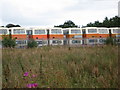
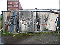
3
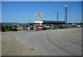
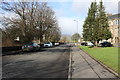
Industrial estate, Beith
At the end of Mains Road.
Image: © Richard Sutcliffe
Taken: 29 Jun 2018
0.17 miles
4
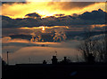
Mist in the valley
Garnock Valley filled with a frosty fog at sunset.
Image: © wfmillar
Taken: 30 Nov 2008
0.20 miles
5
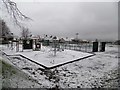
A snowy park in Beith
Orr's Trust Public Park after a light snow flurry.
Image: © Stephen Sweeney
Taken: 9 Jan 2016
0.21 miles
6
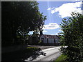
Woodside Lodge
C(S) Listed Mid 19th Century Victorian Gothic Style Lodge House, with Lodge Woods in the foreground, and surrounding farmland.
Image: © Chris Court
Taken: 7 Aug 2005
0.21 miles
7
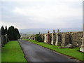
Peace
Boundary wall and headstones in the beautifully tended Beith Cemetery.
Image: © Chris Court
Taken: 20 Nov 2005
0.21 miles
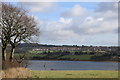
10
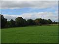
First sign of Autumn. Mains, Beith
Green field but a tint of orange in the trees.
Image: © wfmillar
Taken: 2 Sep 2007
0.25 miles