IMAGES TAKEN NEAR TO
Mains Road, BEITH, KA15 2AF
Introduction
This page details the photographs taken nearby to Mains Road, KA15 2AF by members of the Geograph project.
The Geograph project started in 2005 with the aim of publishing, organising and preserving representative images for every square kilometre of Great Britain, Ireland and the Isle of Man.

There are currently over 7.5m images from over14,400 individuals and you can help contribute to the project by visiting https://www.geograph.org.uk
Image Map
Images are licensed for reuse under creativecommons.org/licenses/by-sa/2.0
Notes
- Clicking on the map will re-center to the selected point.
- The higher the marker number, the further away the image location is from the centre of the postcode.
Image Listing (107 Images Found)
Images are licensed for reuse under creativecommons.org/licenses/by-sa/2.0
Image
Details
Distance
1
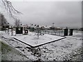
A snowy park in Beith
Orr's Trust Public Park after a light snow flurry.
Image: © Stephen Sweeney
Taken: 9 Jan 2016
0.06 miles
2
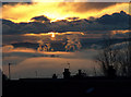
Mist in the valley
Garnock Valley filled with a frosty fog at sunset.
Image: © wfmillar
Taken: 30 Nov 2008
0.10 miles
3
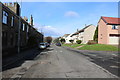
Behind the Cross and Eglinton Street , Beith
Image: © wfmillar
Taken: 14 May 2007
0.10 miles
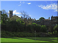
4
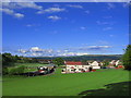
Beith
Looking over common ground to the Garnock Valley. Beith Juniors football ground to the left.
Image: © wfmillar
Taken: 14 May 2007
0.10 miles
6
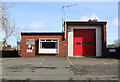
Telephone Exchange Beith
Telephone Exchange on Kings Road Beith. Community hall is to the right of the exchange. 26th July 2009 3.30p.m.
Image: © Gordon Dowie
Taken: 26 Jul 2009
0.13 miles
9
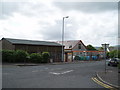
Caledonia Road, Beith
Building straight ahead in the centre is the Co-op.
Image: © Billy McCrorie
Taken: 4 Mar 2019
0.14 miles