IMAGES TAKEN NEAR TO
Viewfield Road, BEITH, KA15 1LZ
Introduction
This page details the photographs taken nearby to Viewfield Road, KA15 1LZ by members of the Geograph project.
The Geograph project started in 2005 with the aim of publishing, organising and preserving representative images for every square kilometre of Great Britain, Ireland and the Isle of Man.

There are currently over 7.5m images from over14,400 individuals and you can help contribute to the project by visiting https://www.geograph.org.uk
Image Map
Images are licensed for reuse under creativecommons.org/licenses/by-sa/2.0
Notes
- Clicking on the map will re-center to the selected point.
- The higher the marker number, the further away the image location is from the centre of the postcode.
Image Listing (7 Images Found)
Images are licensed for reuse under creativecommons.org/licenses/by-sa/2.0
Image
Details
Distance
1
Willowyard Industrial Estate
Many of the units now stand empty.
Image: © Gordon Dowie
Taken: 7 May 2010
0.06 miles
2

Willowyard Industrial Estate
Signs on the entrance to the Beith industrial estate.
Image: © Richard Webb
Taken: 1 Sep 2015
0.13 miles
3
Warehouses
Willowyard Industrial Estate
Image: © Chris Court
Taken: 10 Aug 2005
0.14 miles
4
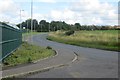
B777, Beith
The road passing Willowyard Industrial Estate.
Image: © Richard Webb
Taken: 1 Sep 2015
0.16 miles
5
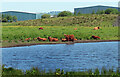
Cattle at Longbar Pool
Highland cattle grazing in the damp conditions at Longbar Pool near Glengarnock with bonded warehouses in the background.
Image: © Mary and Angus Hogg
Taken: 5 Jun 2022
0.19 miles
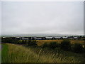
6
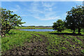
Towards Longbar Pool
A muddy access track leading to a small pool of water in old industrial land with modern whisky bonds in the background.
Image: © Mary and Angus Hogg
Taken: 5 Jun 2022
0.21 miles
7
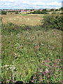
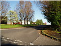
Beith
Looking over very colourful fields from the Willowyard Industrial Estate towards Beith.
Image: © wfmillar
Taken: 9 Aug 2007
0.24 miles