IMAGES TAKEN NEAR TO
Burnhouse, BEITH, KA15 1LJ
Introduction
This page details the photographs taken nearby to KA15 1LJ by members of the Geograph project.
The Geograph project started in 2005 with the aim of publishing, organising and preserving representative images for every square kilometre of Great Britain, Ireland and the Isle of Man.

There are currently over 7.5m images from over14,400 individuals and you can help contribute to the project by visiting https://www.geograph.org.uk
Image Map
Images are licensed for reuse under creativecommons.org/licenses/by-sa/2.0
Notes
- Clicking on the map will re-center to the selected point.
- The higher the marker number, the further away the image location is from the centre of the postcode.
Image Listing (17 Images Found)
Images are licensed for reuse under creativecommons.org/licenses/by-sa/2.0
Image
Details
Distance
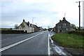
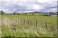
1
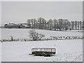
Manor Farm Hotel
A hotel on the right (yellow building) with a fully working farm behind.
Image: © wfmillar
Taken: 9 Feb 2009
0.06 miles
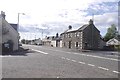
2
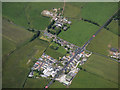
Burnhouse from the air
The A736 Lochlibo Road through the hamlet appears to have been resurfaced and repainted fairly recently.
Image: © Thomas Nugent
Taken: 28 Jun 2019
0.08 miles
3
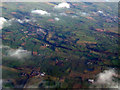
Dunlop from the air
Looking over Burnhouse (left foreground) towards Dunlop. Stewarton is also visible, towards the top right of the photo.
Image: © Thomas Nugent
Taken: 23 Jan 2012
0.08 miles
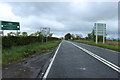
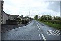
10
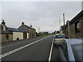
Road (A736) passing through Burnhouse
Looking northward.
Image: © Peter Wood
Taken: 14 Sep 2016
0.15 miles