IMAGES TAKEN NEAR TO
Barrmill, BEITH, KA15 1LD
Introduction
This page details the photographs taken nearby to KA15 1LD by members of the Geograph project.
The Geograph project started in 2005 with the aim of publishing, organising and preserving representative images for every square kilometre of Great Britain, Ireland and the Isle of Man.

There are currently over 7.5m images from over14,400 individuals and you can help contribute to the project by visiting https://www.geograph.org.uk
Image Map
Images are licensed for reuse under creativecommons.org/licenses/by-sa/2.0
Notes
- Clicking on the map will re-center to the selected point.
- The higher the marker number, the further away the image location is from the centre of the postcode.
Image Listing (4 Images Found)
Images are licensed for reuse under creativecommons.org/licenses/by-sa/2.0
Image
Details
Distance
1
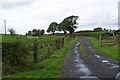
Farm entrance
Typical Ayrshire farm entrance with the name ' Mid Lugtonridge '.
Image: © Alex Mcnaughton
Taken: 19 Sep 2006
0.02 miles
2
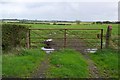
Iron gate
An iron gate for a field with only a tyre in it.
Image: © Alex Mcnaughton
Taken: 19 Sep 2006
0.02 miles
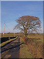
4
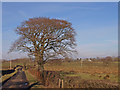
Farm Road
Lugtonridge Farm in the distance.
Image: © wfmillar
Taken: 19 Feb 2010
0.18 miles