IMAGES TAKEN NEAR TO
Kilwinning Road, BEITH, KA15 1JZ
Introduction
This page details the photographs taken nearby to Kilwinning Road, KA15 1JZ by members of the Geograph project.
The Geograph project started in 2005 with the aim of publishing, organising and preserving representative images for every square kilometre of Great Britain, Ireland and the Isle of Man.

There are currently over 7.5m images from over14,400 individuals and you can help contribute to the project by visiting https://www.geograph.org.uk
Image Map
Images are licensed for reuse under creativecommons.org/licenses/by-sa/2.0
Notes
- Clicking on the map will re-center to the selected point.
- The higher the marker number, the further away the image location is from the centre of the postcode.
Image Listing (12 Images Found)
Images are licensed for reuse under creativecommons.org/licenses/by-sa/2.0
Image
Details
Distance
1
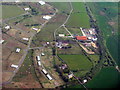
DM Beith and Drumbuie Farm
A Ministry of Defence munitions depot at Barrmill near Beith https://en.wikipedia.org/wiki/Barrmill,_North_Ayrshire#DM_Beith.
Image: © M J Richardson
Taken: 11 May 2016
0.09 miles
2
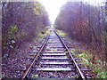
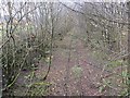
Giffen Station
Taken on the now disused Lugton to RNAD Beith line, looking north east towards Giffen Station. One of the three intact platforms can be seen further down the track, though heavily overgrown.
Image: © SGM
Taken: 14 Nov 2005
0.12 miles
3
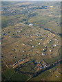
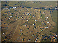
DM Beith from the air
Beith village can be seen in the distance.
Image: © Thomas Nugent
Taken: 16 Mar 2016
0.17 miles
4
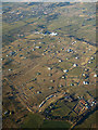
DM Beith from the air
Beith village can be seen in the distance.
Image: © Thomas Nugent
Taken: 16 Mar 2016
0.17 miles
5

DM Beith from the air
Beith village can be seen in the distance.
Image: © Thomas Nugent
Taken: 16 Mar 2016
0.17 miles
6
DM Beith from the air
The B706 Barmill Road can be seen beyond the depot.
Image: © Thomas Nugent
Taken: 16 Mar 2016
0.17 miles
7
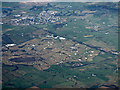
DM Beith from the air
Most of the site can be seen in this view, taken from an aircraft above Cunninghamhead.
Image: © Thomas Nugent
Taken: 28 Jan 2019
0.17 miles
8
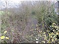
Lugton to RNAD Beith line
Now overgrown, this spur served RNAD Beith.
Image: © Richard Webb
Taken: 15 Nov 2014
0.18 miles
9
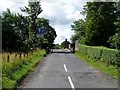
Narrowed Road Bridge
Road bridge over the now disused rail line serving the Royal Naval Armanent Depot at Beith. Bridge has recently been narrowed due to weight restriction. 25th July 2009 12.00p.m.
Image: © Gordon Dowie
Taken: 25 Jul 2009
0.19 miles
10
Lugton to RNAD Beith line
A spur that used to serve RNAD Beith. The tracks are still there amongst the trees.
Image: © Richard Webb
Taken: 15 Nov 2014
0.20 miles