IMAGES TAKEN NEAR TO
Dalry Road, BEITH, KA15 1JJ
Introduction
This page details the photographs taken nearby to Dalry Road, KA15 1JJ by members of the Geograph project.
The Geograph project started in 2005 with the aim of publishing, organising and preserving representative images for every square kilometre of Great Britain, Ireland and the Isle of Man.

There are currently over 7.5m images from over14,400 individuals and you can help contribute to the project by visiting https://www.geograph.org.uk
Image Map
Images are licensed for reuse under creativecommons.org/licenses/by-sa/2.0
Notes
- Clicking on the map will re-center to the selected point.
- The higher the marker number, the further away the image location is from the centre of the postcode.
Image Listing (3 Images Found)
Images are licensed for reuse under creativecommons.org/licenses/by-sa/2.0
Image
Details
Distance
1
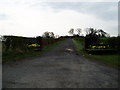
Entrance to Barcosh Farm
Off the A737 Beith to Dalry Road the track leads up to Barcosh.
Image: © Gordon Dowie
Taken: 27 Apr 2010
0.10 miles
2
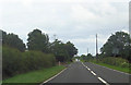
A737 passing Barcosh farm
Power lines cross road ahead
Image: © John Firth
Taken: 27 Jul 2012
0.17 miles
3
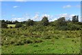
Rough grazing near Beith
Rough ground beside the A737 with evidence of mining.
Image: © Richard Webb
Taken: 1 Sep 2015
0.19 miles