IMAGES TAKEN NEAR TO
Willowyard Road, BEITH, KA15 1JH
Introduction
This page details the photographs taken nearby to Willowyard Road, KA15 1JH by members of the Geograph project.
The Geograph project started in 2005 with the aim of publishing, organising and preserving representative images for every square kilometre of Great Britain, Ireland and the Isle of Man.

There are currently over 7.5m images from over14,400 individuals and you can help contribute to the project by visiting https://www.geograph.org.uk
Image Map
Images are licensed for reuse under creativecommons.org/licenses/by-sa/2.0
Notes
- Clicking on the map will re-center to the selected point.
- The higher the marker number, the further away the image location is from the centre of the postcode.
Image Listing (5 Images Found)
Images are licensed for reuse under creativecommons.org/licenses/by-sa/2.0
Image
Details
Distance
1
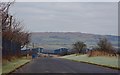
Bonded Warehouses, Beith, North Ayrshire
Bonded warehouses as seen from Willowyard Road, Beith on a frosty January morning.
The Kilbirnie countryside is in the distance.
Image: © Mark S
Taken: 2 Jan 2019
0.08 miles
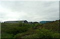
3
Warehouses
Willowyard Industrial Estate
Image: © Chris Court
Taken: 10 Aug 2005
0.19 miles
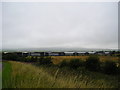
4
Unnamed Burn, Beith
This burn (almost completely hidden by the fantastic grasses) flows through Willowyard Industrial estate, under Glasgow/Ayr railway line and eventually into Kilbirnie Loch.
Image: © wfmillar
Taken: 9 Aug 2007
0.25 miles
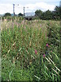
5
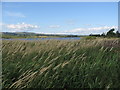
Grass
This view of Kilbrinie Loch was taken over the 2 metre high grasses. I had to hold the camera above head height.
Image: © wfmillar
Taken: 9 Aug 2007
0.25 miles