IMAGES TAKEN NEAR TO
McHardy Crescent, BEITH, KA15 1HS
Introduction
This page details the photographs taken nearby to McHardy Crescent, KA15 1HS by members of the Geograph project.
The Geograph project started in 2005 with the aim of publishing, organising and preserving representative images for every square kilometre of Great Britain, Ireland and the Isle of Man.

There are currently over 7.5m images from over14,400 individuals and you can help contribute to the project by visiting https://www.geograph.org.uk
Image Map
Images are licensed for reuse under creativecommons.org/licenses/by-sa/2.0
Notes
- Clicking on the map will re-center to the selected point.
- The higher the marker number, the further away the image location is from the centre of the postcode.
Image Listing (28 Images Found)
Images are licensed for reuse under creativecommons.org/licenses/by-sa/2.0
Image
Details
Distance
1
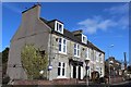
Millbarr Grove, Barrmill
A modern housing development with a street name that someone must have thought was a good idea.
Image: © Richard Dorrell
Taken: 11 Aug 2021
0.02 miles
2
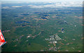
Barmill from the air
The bonded warehouses are prominent, Paisley and Glasgow can be seen in the distance.
Image: © Thomas Nugent
Taken: 15 May 2016
0.04 miles
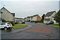
3
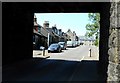
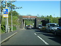
View through the bridge
Houses on Dunlop Road (B706) Barrmill, seen through the railway bridge.
Image: © Richard Sutcliffe
Taken: 29 Jun 2018
0.05 miles
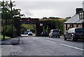
4
B706 Dunlop Road at Barrmill railway bridge
Image: © Colin Pyle
Taken: 10 Jun 2015
0.06 miles
5
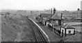
Barrmill Station
View eastward, towards Lugton; station on Lugton - Beith branch (former G&SW & Caledonian Joint). Line going to right is former Caledonian line to Giffen, there joining the Caledonian line from Glasgow to Ardrossan (Montgomery Pier) via Kilwinning; that line lost its local passenger services west of Uplawmoor on 4/7/32 and Montgomery Pier closed on 6/5/68. Barrmill station closed on 5/11/62; Barrmill - Beith closed on 5/10/64, but a remnant of the branch from Lugton remains available (but now rarely used) to serve the Beith Naval Armaments Depot), just east of Barrmill. [A complicated story]
Image: © Ben Brooksbank
Taken: 26 Sep 1961
0.06 miles
6
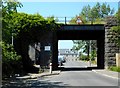
Former railway bridge, Barrmill
The bridge used to carry the railway over the B706, but the railway has been out of use for some time.
Image: © Richard Sutcliffe
Taken: 29 Jun 2018
0.06 miles
7
Rail Bridge at Barrmill
Now disused rail bridge, rails in place but unused since early 90's 12th August 2009
Image: © Gordon Dowie
Taken: 12 Aug 2009
0.06 miles
8
Railway bridge, Balgray Road
The railway that once ran beneath this bridge has long-since been dismantled.
See: Image
Image: © Richard Dorrell
Taken: 11 Aug 2021
0.07 miles
9
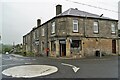
Fast food outlet, Barrmill
Occupying a building clearly dated 1900, and presumably at one time the village shop and (probably) post office, the premises is now named 'Nosh', and specialises in take-away hot and cold food and drinks.
Image: © Richard Dorrell
Taken: 11 Aug 2021
0.07 miles