IMAGES TAKEN NEAR TO
Barrmill Road, BEITH, KA15 1HB
Introduction
This page details the photographs taken nearby to Barrmill Road, KA15 1HB by members of the Geograph project.
The Geograph project started in 2005 with the aim of publishing, organising and preserving representative images for every square kilometre of Great Britain, Ireland and the Isle of Man.

There are currently over 7.5m images from over14,400 individuals and you can help contribute to the project by visiting https://www.geograph.org.uk
Image Map
Images are licensed for reuse under creativecommons.org/licenses/by-sa/2.0
Notes
- Clicking on the map will re-center to the selected point.
- The higher the marker number, the further away the image location is from the centre of the postcode.
Image Listing (12 Images Found)
Images are licensed for reuse under creativecommons.org/licenses/by-sa/2.0
Image
Details
Distance
1
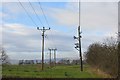
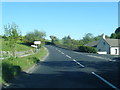
Near Craighouse, Beith
Wet grassland beside the former railway between Beith and Glasgow.
Image: © Richard Webb
Taken: 15 Nov 2014
0.13 miles
2
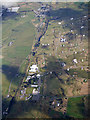
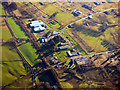
DM Beith from the air
Looking along the disused Glasgow, Barrhead & Kilmarnock Railway branch line from Lugton to Beith.
Image: © Thomas Nugent
Taken: 17 Apr 2017
0.13 miles
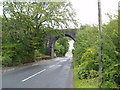
3
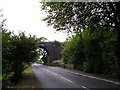
Old Railway Bridge
Old railway bridge, carrying the dismantled London Midland and Scottish Railway Co. line which used to serve Beith Town Railway Station.
Image: © Chris Court
Taken: 31 Aug 2005
0.13 miles
4
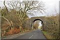
Railway bridge near Beith
Near the munitions depot.
Image: © Richard Webb
Taken: 15 Nov 2014
0.14 miles
6
DM Beith from the air
The northernmost corner of the complex.
Image: © Thomas Nugent
Taken: 3 Dec 2018
0.16 miles
7
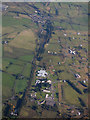
DM Beith from the air
The course of the former Glasgow, Barrhead and Kilmarnock Joint Railway line can be seen running vertically through the centre of the photo. The bonded warehouses near Barmill are also visible in the left distance.
Image: © Thomas Nugent
Taken: 15 May 2016
0.16 miles
8
DM Beith from the air
Looking along the disused Glasgow, Barrhead & Kilmarnock Railway branch line which ran from Lugton to Beith. Barmill is at the top of the photo.
Image: © Thomas Nugent
Taken: 25 Sep 2017
0.18 miles
9
Railway Bridge
Railway bridge for the line that once ran from Lugton to Beith. 3rd August 2009 2.50pm
Image: © Gordon Dowie
Taken: 3 Aug 2009
0.18 miles
10
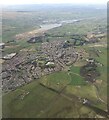
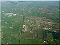
Beith from the air
The A737 road skirts around the south and east sides of the town. The route of the former Beith branch of the Glasgow, Barrhead & Kilmarnock Joint Railway can be clearly seen in the foreground. This five mile line closed to passengers in November 1962 and to freight in 1964.
Barr Loch, Castle Semple Loch and Lochwinnoch can be seen in the distance.
Image: © Thomas Nugent
Taken: 7 Apr 2022
0.19 miles