IMAGES TAKEN NEAR TO
Kirk Road, BEITH, KA15 1EA
Introduction
This page details the photographs taken nearby to Kirk Road, KA15 1EA by members of the Geograph project.
The Geograph project started in 2005 with the aim of publishing, organising and preserving representative images for every square kilometre of Great Britain, Ireland and the Isle of Man.

There are currently over 7.5m images from over14,400 individuals and you can help contribute to the project by visiting https://www.geograph.org.uk
Image Map
Images are licensed for reuse under creativecommons.org/licenses/by-sa/2.0
Notes
- Clicking on the map will re-center to the selected point.
- The higher the marker number, the further away the image location is from the centre of the postcode.
Image Listing (93 Images Found)
Images are licensed for reuse under creativecommons.org/licenses/by-sa/2.0
Image
Details
Distance
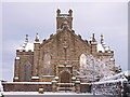
4
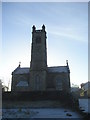
The High Church, Beith
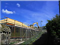
The site of the old Beith Academy now demolished. Preparing site for housing.
Image: © wfmillar
Taken: 9 May 2007
0.03 miles
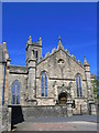
5
At the Third Stroke
Beith High Church at 12 O' Clock Xmas Day 2005.
Image: © Chris Court
Taken: 25 Dec 2005
0.04 miles
6
New build
This path led up to Beith Academy (now demolished). Two new houses are being built behind the bank. Beyond the excavator there will be more new housing.
Image: © wfmillar
Taken: 9 May 2007
0.05 miles
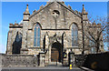
7
Looking up the Strand, Beith
High church tower in the background. To the left the remains of "the fountain", this has been vandalised over the years.
Image: © wfmillar
Taken: 9 May 2007
0.06 miles
8
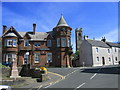
Barrmill Road, Beith
The large house to the left is called Knockbuckle which is B listed.
Image: © wfmillar
Taken: 23 Dec 2009
0.06 miles
9
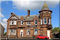
Clydesdale Bank, Braehead, Beith
Category B-listed. Built 1906 in red Mauchline sandstone and said to be the only red sandstone building in the town.
Image: © Leslie Barrie
Taken: 16 May 2014
0.08 miles
10
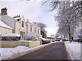
The Foley, Beith
A short cut from the Cross to the Backburn. Although the centre of the town was demolished some old bits remain.
Image: © wfmillar
Taken: 9 May 2007
0.08 miles