IMAGES TAKEN NEAR TO
Hawthorn Crescent, BEITH, KA15 1DF
Introduction
This page details the photographs taken nearby to Hawthorn Crescent, KA15 1DF by members of the Geograph project.
The Geograph project started in 2005 with the aim of publishing, organising and preserving representative images for every square kilometre of Great Britain, Ireland and the Isle of Man.

There are currently over 7.5m images from over14,400 individuals and you can help contribute to the project by visiting https://www.geograph.org.uk
Image Map
Images are licensed for reuse under creativecommons.org/licenses/by-sa/2.0
Notes
- Clicking on the map will re-center to the selected point.
- The higher the marker number, the further away the image location is from the centre of the postcode.
Image Listing (4 Images Found)
Images are licensed for reuse under creativecommons.org/licenses/by-sa/2.0
Image
Details
Distance
1
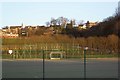
Astroturf
The all weather astroturf playing field in Beith. In the background is Beith Juniors football pitch.
Image: © Alex Mcnaughton
Taken: 9 Feb 2003
0.16 miles
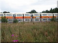
3
Industrial estate, Beith
At the end of Mains Road.
Image: © Richard Sutcliffe
Taken: 29 Jun 2018
0.22 miles
4
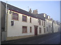
Eglinton St.
Eglinton Inn and Townhouses in Eglinton St. Beith.
Image: © Chris Court
Taken: 25 Dec 2005
0.22 miles