IMAGES TAKEN NEAR TO
McMillan Crescent, BEITH, KA15 1BP
Introduction
This page details the photographs taken nearby to McMillan Crescent, KA15 1BP by members of the Geograph project.
The Geograph project started in 2005 with the aim of publishing, organising and preserving representative images for every square kilometre of Great Britain, Ireland and the Isle of Man.

There are currently over 7.5m images from over14,400 individuals and you can help contribute to the project by visiting https://www.geograph.org.uk
Image Map
Images are licensed for reuse under creativecommons.org/licenses/by-sa/2.0
Notes
- Clicking on the map will re-center to the selected point.
- The higher the marker number, the further away the image location is from the centre of the postcode.
Image Listing (12 Images Found)
Images are licensed for reuse under creativecommons.org/licenses/by-sa/2.0
Image
Details
Distance
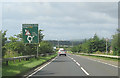
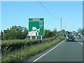
2
A737 on bridge over long disused railway
Image: © Colin Pyle
Taken: 10 Jun 2015
0.14 miles
3
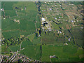
DM Beith from the air
The course of the former Glasgow, Barrhead and Kilmarnock Joint Railway line can be seen running vertically through the centre of the photo.
Image: © Thomas Nugent
Taken: 15 May 2016
0.14 miles
4
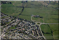
Beith from the air
Manrahead Roundabout where the A737 is joined by the B777 and B7049 is prominent.
Image: © Thomas Nugent
Taken: 21 Apr 2022
0.16 miles
5
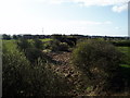
Old Rail line
Overgrown remains of the Beith railway line closed in the 1960's.
Image: © Gordon Dowie
Taken: 21 Apr 2010
0.17 miles
7
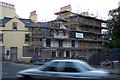
Cross scaffolds
The Cross in Beith wearing a scaffold during the refurbishment with ( partial ) lottery money.
Image: © Alex Mcnaughton
Taken: 11 Sep 2003
0.21 miles
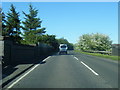
8
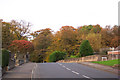
Autumn colours
Autumn in Beith where Dalry Road starts at the junction with Glebe Road.
Image: © Alex Mcnaughton
Taken: 15 Oct 2003
0.21 miles
9
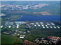
Bonded warehouses from the air
By Kilbirnie Loch, between Glengarnock, Kilbirnie (in the distance) and Beith. On the outer approach to Glasgow airport on a flight from Luton.
Image: © Thomas Nugent
Taken: 4 Sep 2010
0.21 miles
10
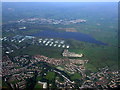
Beith and Kilbirnie from the air
Beith is nearer the camera, with Kilbirnie Loch and the bonded warehouss in the centre. Viewed from a Glasgow bound flight from Luton.
Image: © Thomas Nugent
Taken: 4 Sep 2010
0.21 miles