IMAGES TAKEN NEAR TO
Caprington Avenue, KILMARNOCK, KA1 4SL
Introduction
This page details the photographs taken nearby to Caprington Avenue, KA1 4SL by members of the Geograph project.
The Geograph project started in 2005 with the aim of publishing, organising and preserving representative images for every square kilometre of Great Britain, Ireland and the Isle of Man.

There are currently over 7.5m images from over14,400 individuals and you can help contribute to the project by visiting https://www.geograph.org.uk
Image Map
Images are licensed for reuse under creativecommons.org/licenses/by-sa/2.0
Notes
- Clicking on the map will re-center to the selected point.
- The higher the marker number, the further away the image location is from the centre of the postcode.
Image Listing (11 Images Found)
Images are licensed for reuse under creativecommons.org/licenses/by-sa/2.0
Image
Details
Distance
3
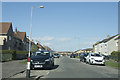
The edge of Kilmarnock
We are passing along Loreny Drive, which looks as if it is composed of what was once council built housing.
Image: © Malcolm Neal
Taken: 9 Apr 2019
0.12 miles
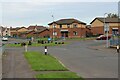
4
Caprington Avenue Kilmarnock
Leading into the Shortlees housing scheme.
Image: © Gordon Dowie
Taken: 2 May 2010
0.13 miles
6
Caprington Avenue, Kilmarnock
Local authority housing area on the south side of the town.
Image: © Mary and Angus Hogg
Taken: 8 Jun 2013
0.16 miles
7
Caprington Avenue, Kilmarnock
Local authority housing area on the south side of the town.
Image: © Mary and Angus Hogg
Taken: 8 Jun 2013
0.18 miles
8
Langside Avenue, Shortlees, Kilmarnock
Don't suppose you see many avenues like this!
Image: © wfmillar
Taken: 10 Nov 2011
0.19 miles
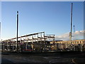
9
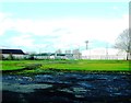
Demolished play area off Caprington Avenue
Image: © Alex McGregor
Taken: 21 Nov 2013
0.20 miles
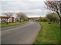
10
Shortlees Road
Local authority housing area on the south side of Kilmarnock.
Image: © Mary and Angus Hogg
Taken: 5 Mar 2017
0.24 miles