IMAGES TAKEN NEAR TO
Shortlees Road, KILMARNOCK, KA1 4RG
Introduction
This page details the photographs taken nearby to Shortlees Road, KA1 4RG by members of the Geograph project.
The Geograph project started in 2005 with the aim of publishing, organising and preserving representative images for every square kilometre of Great Britain, Ireland and the Isle of Man.

There are currently over 7.5m images from over14,400 individuals and you can help contribute to the project by visiting https://www.geograph.org.uk
Image Map
Images are licensed for reuse under creativecommons.org/licenses/by-sa/2.0
Notes
- Clicking on the map will re-center to the selected point.
- The higher the marker number, the further away the image location is from the centre of the postcode.
Image Listing (9 Images Found)
Images are licensed for reuse under creativecommons.org/licenses/by-sa/2.0
Image
Details
Distance
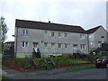
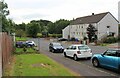
2
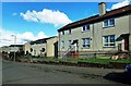
Shortlees Road
Local authority housing area on the south side of Kilmarnock.
Image: © Mary and Angus Hogg
Taken: 5 Mar 2017
0.10 miles
3
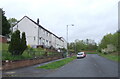
Loreny Drive, Kilmarnock
Local authority housing on the south side of Kilmarnock.
Image: © JThomas
Taken: 21 May 2021
0.12 miles
4
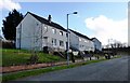
Craigie Road
Local authority housing area in Shortlees, on the southern edge of Kilmarnock.
Image: © Mary and Angus Hogg
Taken: 5 Mar 2017
0.14 miles
5
Langside Avenue, Shortlees, Kilmarnock
Don't suppose you see many avenues like this!
Image: © wfmillar
Taken: 10 Nov 2011
0.15 miles
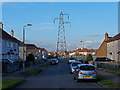
6
Housing in Shortlees at the southern tip of Kilmarnock
Image: © Alan Reid
Taken: 15 Sep 2021
0.16 miles