IMAGES TAKEN NEAR TO
Barnweil Road, KILMARNOCK, KA1 4JG
Introduction
This page details the photographs taken nearby to Barnweil Road, KA1 4JG by members of the Geograph project.
The Geograph project started in 2005 with the aim of publishing, organising and preserving representative images for every square kilometre of Great Britain, Ireland and the Isle of Man.

There are currently over 7.5m images from over14,400 individuals and you can help contribute to the project by visiting https://www.geograph.org.uk
Image Map (Loading...)


Getting Data...Please wait
Leaflet Map data © OpenStreetMap
Images are licensed for reuse under creativecommons.org/licenses/by-sa/2.0
Notes
- Clicking on the map will re-center to the selected point.
- The higher the marker number, the further away the image location is from the centre of the postcode.
Image Listing (9 Images Found)
Images are licensed for reuse under creativecommons.org/licenses/by-sa/2.0
Image
Details
Distance
4

Riccarton Nursery School
On Old Street, Riccarton, in a building dated 1908 that was presumably originally the school for the area.
Image: © M J Richardson
Taken: 26 Jun 2013
0.16 miles
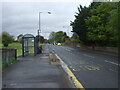
7
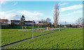
Play Ground, Shortlees, Kilmarnock
Adjacent to Lainshaw Avenue.
Image: © wfmillar
Taken: 14 Nov 2011
0.23 miles
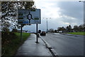
8
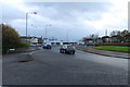
Turning from the A71 at Riccarton towards Kilmarnock
Image: © Andrew Abbott
Taken: 7 May 2010
0.24 miles