IMAGES TAKEN NEAR TO
Holmquarry Road, KILMARNOCK, KA1 4EP
Introduction
This page details the photographs taken nearby to Holmquarry Road, KA1 4EP by members of the Geograph project.
The Geograph project started in 2005 with the aim of publishing, organising and preserving representative images for every square kilometre of Great Britain, Ireland and the Isle of Man.

There are currently over 7.5m images from over14,400 individuals and you can help contribute to the project by visiting https://www.geograph.org.uk
Image Map
Images are licensed for reuse under creativecommons.org/licenses/by-sa/2.0
Notes
- Clicking on the map will re-center to the selected point.
- The higher the marker number, the further away the image location is from the centre of the postcode.
Image Listing (69 Images Found)
Images are licensed for reuse under creativecommons.org/licenses/by-sa/2.0
Image
Details
Distance
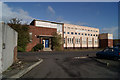
1
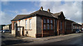
Council Building of Holmquarry Road
Image: © Thomas Nugent
Taken: 27 Oct 2010
0.02 miles
2
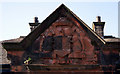
Kilmarnock Corporation coat of arms
Image: © Thomas Nugent
Taken: 27 Oct 2010
0.02 miles
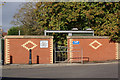
3
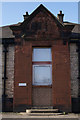
Council Building off Holmquarry Road
This appears to have been a door originally. Note the Kilmarnock Corporation coat of arms above the window Image See the building here Image
Image: © Thomas Nugent
Taken: 27 Oct 2010
0.02 miles
4
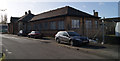
Council Building off Holmquarry Road
One of several East Ayrshire Council buildings in this former industrial area. See also Image & Image The street is not named on the map.
Image: © Thomas Nugent
Taken: 27 Oct 2010
0.02 miles
5
Old Bakery on Holmquarry Road
Present use unknown.
Image: © Thomas Nugent
Taken: 27 Oct 2010
0.06 miles
6

Old Bakery on Holmquarry Road
Present use unknown.
Image: © Thomas Nugent
Taken: 27 Oct 2010
0.06 miles
7
Flood defences at Kilmarnock water
At the footbridge between Burnside Street and Fairyhill Road. The gate to the right can be slid into place when flooding is expected.
Image: © Thomas Nugent
Taken: 27 Oct 2010
0.08 miles
8
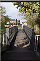
Footbridge over Kilmarnock Water
Viewed from Burnside Street, looking towards Fairyhill Road.
Image: © Thomas Nugent
Taken: 27 Oct 2010
0.08 miles
9

Flood defences at Kilmarnock water
The gate can be closed to form a watertight seal when flooding is forecast. Viewed from the footbridge between Burnside Street and Fairyhill Road.
Image: © Thomas Nugent
Taken: 27 Oct 2010
0.08 miles
10
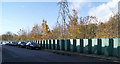
Flood defences at Kilmarnock water
No nonsense barrier by Burnside Street.
Image: © Thomas Nugent
Taken: 27 Oct 2010
0.10 miles