IMAGES TAKEN NEAR TO
Glengarnock, BEITH, KA14 3BT
Introduction
This page details the photographs taken nearby to KA14 3BT by members of the Geograph project.
The Geograph project started in 2005 with the aim of publishing, organising and preserving representative images for every square kilometre of Great Britain, Ireland and the Isle of Man.

There are currently over 7.5m images from over14,400 individuals and you can help contribute to the project by visiting https://www.geograph.org.uk
Image Map
Images are licensed for reuse under creativecommons.org/licenses/by-sa/2.0
Notes
- Clicking on the map will re-center to the selected point.
- The higher the marker number, the further away the image location is from the centre of the postcode.
Image Listing (4 Images Found)
Images are licensed for reuse under creativecommons.org/licenses/by-sa/2.0
Image
Details
Distance
1
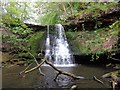
The Linn Spout or Tianna Falls
Linn spout Waterfall also called Tianna Falls on Powgree Burn with the ruins of Kersland Mill nearby
Image: © Stephen Clark
Taken: 25 May 2015
0.05 miles
2
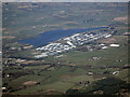
Glengarnock bonded warehouses from the air
Chivas Regal whisky bonded warehouses in the east side of Kilbirnie Loch.
Image: © Thomas Nugent
Taken: 21 Apr 2022
0.16 miles
3
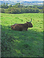
Highland Cow
On Crawfield Farm near Longbar.
Image: © wfmillar
Taken: 9 Aug 2007
0.23 miles
4
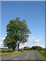
B777
This road runs between Beith and Longbar. The red brick building is an electrical sub station.
Image: © wfmillar
Taken: 9 Aug 2007
0.24 miles